Zoom Earth - Weather Forecast
- 4.7
- Rating
- 5.00M
- Installs
- Free
- Price

 Analysis by App-foxy
Weather apps usually ask me to look at a forecast, but Zoom Earth takes a more visual route. Developed by Neave Interactive, this free weather app is built around maps, live-looking weather layers, storm awareness, and a broader view of what is happening around me. I find it most useful when I want to understand the movement of rain or a developing weather system rather than simply read the temperature for the afternoon.
That difference matters. A conventional forecast app is often best for a quick glance at hourly conditions, while Zoom Earth feels closer to a weather map I can explore. I can move around the globe, zoom into an area, and use the visual information to answer practical questions: Is that band of rain heading toward my route? Is a storm system approaching from the coast? Does the wider pattern explain why the local forecast keeps changing?
My overall impression is positive, but it is not an automatic replacement for every weather service. It is strongest for visual context and storm tracking, while people who only want a simple notification and a compact daily forecast may find it more elaborate than necessary.
You May Also Like

 Blood Strike: 2.5 Anniversary
Blood Strike’s Loadouts Turn Every Drop Into a Tactical Gamble
A close look at Blood Strike’s custom loadouts: how fast access to signature weapons reshapes its battle royale rhythm, rewards preparation, and narrows the gap between fights.

 Pandora - Music & Podcasts
Pandora’s Music Is Easy to Start, but Harder to Recover
Pandora’s strength is its low-effort path from a seed to a station. Its weak spot is how much confidence it asks you to place in connection, setup, and quiet recovery.

 8 Ball Pool
 Is Built on Rivalries, Rematches, and Routine
A close look at the rivalries, rematches, shared routines, and unanswered safety questions that turn a quick pool match into a persistent mobile community.

 Samsung Music
’s Quiet Strength Is Playing What You Already Own
Its reach comes less from spectacle than from dependable access to a personal library. That simplicity is both the app’s strongest retention engine and its ceiling.

 AccuWeather: Weather Radar
AccuWeather Review: A Quick, Clear Forecast for Everyday Decisions
For everyday plans, the best forecast is the one you can understand quickly. AccuWeather makes rain timing, radar, and local conditions easy to act on, with a few trade-offs.

 Hill Climb Racing
Why Hill Climb Racing Still Turns Crashes Into One More Run
A tiny car, a bumpy hill and one more upgrade: Hill Climb Racing keeps resurfacing because its simple chaos makes every near-miss feel personal.
More From Our News Desk



What Zoom Earth is like in everyday use
I find Zoom Earth most useful when I treat it as an investigation tool rather than expecting it to settle every weather question at a glance. In this section, I’ll explain how I move between a local view and the wider map, and why checking a destination as well as home can prevent a last-minute surprise. That same hands-on approach also brings a few trade-offs worth considering.
A weather map made for looking around
The first thing I notice is that the app encourages exploration. Instead of opening on a wall of numbers, I can use the map as the main starting point. The experience makes sense for anyone who thinks spatially: weather becomes something moving across a region, not just a percentage beside a city name.
The hurricane tracker is one of the clearest reasons to install it. During an active tropical system, I can follow the wider path and see how the storm relates to coastlines and nearby places. That is more useful than repeatedly searching for separate news updates, especially when I want a quick visual sense of direction. I would still treat official emergency guidance as the authority for safety decisions, but the map is a convenient way to maintain awareness.
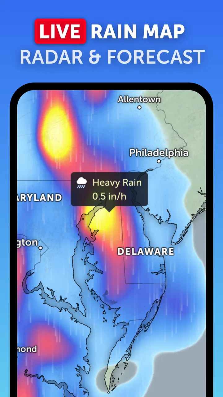
The rain map is equally practical in ordinary situations. Before leaving for a walk, cycling to work, or driving across town, I can check whether precipitation is sitting over my route or building nearby. A radar-style view does not guarantee that my exact street will stay dry, yet it often gives better immediate context than a single icon representing the next hour.
Why the visual approach feels different
Most familiar weather apps are designed around a selected location. They show current conditions, an hourly strip, and a multi-day outlook. Zoom Earth is more comfortable when I want to compare places or understand the larger picture. I can begin with my neighborhood, zoom out to the surrounding region, and then see whether the weather is part of a much bigger system.
That workflow is particularly helpful when forecasts disagree. Rather than choosing one prediction blindly, I can look at the moving weather pattern and form a more sensible expectation. For example, a clear local forecast may feel less reassuring if a large area of precipitation is visibly approaching from the west. Conversely, scattered showers on a forecast can look less concerning when the map shows them breaking apart before reaching my area.
This is also where the app demands a little more attention than a basic alternative. A map can show a lot at once, and new users may need time to understand what they are seeing. I prefer that trade-off, because the extra context is the main reason I would open this app in the first place.
How I use it before going out
A realistic example is a weekend trip by car. I would first check the destination, then zoom out to inspect the route and the surrounding weather. If rain is visible near the departure point but not farther along the journey, I might delay leaving briefly or prepare for a wet first section. If the entire route sits inside a broad system, I know that packing a jacket is not just a reaction to one local forecast tile.
For a shorter errand, I use the same idea in a simpler way. I check the rain map before taking the dog out, look for movement toward the neighborhood, and decide whether a quick walk is sensible. The app does not remove uncertainty, but it helps me make a decision based on the shape and direction of the weather rather than a single static symbol.
Cost, free access, and what paid value means
Zoom Earth can be installed for free, which makes trying it straightforward. The app is rated for Everyone, so it is presented as suitable for a general audience rather than a specialist or adult-only tool. Its current version is 5.0.1, and it runs on Android 8.0 or later, making the minimum system requirement relatively accessible for many existing phones.
There are in-app purchases listed from $1.99 to $11.99 per item. I would not describe the app as requiring payment just to discover whether its map-based approach suits me. The sensible way to evaluate it is to begin with the free experience, use it during normal weather and a few rainy days, and then decide whether any paid option adds enough value to justify the purchase.
That distinction is important because the app’s main appeal is already clear without treating it like a subscription decision. If I only need a basic forecast, I may not gain enough from paying for extras. If I regularly monitor storms, plan outdoor activities around rain movement, or want a more visual weather reference, paid value could make more sense, but I would judge that against the specific functions I actually use rather than the headline alone.
I also appreciate that the price range is clear enough to set expectations, while the free starting point lowers the risk of testing it. My advice is not to buy immediately. First, make the rain map part of a real routine: check it before commuting, compare it with what you see outside, and see whether the broader view changes your decisions. If it becomes a tool I open repeatedly, then an optional purchase may feel reasonable.
What kind of value the app delivers
The strongest value is not simply “more weather information.” It is the way the information is arranged. A local forecast tells me what may happen at one place; a map helps me understand what is happening around that place. That difference can save time when I am trying to decide whether to leave now, wait, change a route, or prepare for a wider weather event.
The storm-tracking angle adds another useful layer. I do not need to be a weather enthusiast to benefit from seeing a system’s position in relation to my plans. A family near a coastline, a traveler checking a destination, or someone organizing an outdoor event can use that context to ask better questions before relying on a forecast.
Another non-obvious strength is that the map encourages comparison. I can look beyond the default location and see whether a nearby town has the same conditions or whether the weather is uneven across the region. That is useful for day trips and commutes, where the forecast at home may not represent the conditions at the destination.
The app also works well as a companion to, rather than a replacement for, a conventional forecast. I might use a standard weather app for a notification or a quick temperature check, then open Zoom Earth when I need to investigate rain or storm movement. This combination is more practical for me than forcing one app to do every job.
Trade-offs I noticed while using it
The map’s detail is valuable, but I’ve learned to read it as context rather than a promise about the weather on my exact street. I’ll look at the direction and extent of a rain area, then use a familiar forecast or official alert when the decision calls for a specific time or safety advice. That balance helps clarify where the app earns its place—and where another source is the better fit.
Maps provide context, but they also require interpretation
The main limitation is the same feature that makes the app interesting: visual weather layers need interpretation. A colored area on a map can look dramatic, but it does not automatically tell me how heavy the rain will be at my exact location or whether it will last for ten minutes or several hours. I need to consider movement, scale, and timing instead of treating the display as a guarantee.
That makes Zoom Earth less suitable for someone who wants a single sentence such as “take an umbrella at three o’clock.” The app can support that decision, but it asks me to look and think. For some users, that is useful control; for others, it may feel like unnecessary work compared with a simpler forecast screen.
It is not my only source for serious weather decisions
When a storm could affect safety, I would not rely on a map alone. I would check official alerts and local guidance as well. Zoom Earth is valuable for visual orientation, but an attractive moving map should not replace instructions from emergency services. This is an important trade-off for anyone who might mistake a convenient tracker for a complete warning system.
I also find that the app’s usefulness depends on the situation. On a calm day with predictable conditions, I may open it once and then return to a simpler weather widget. During unsettled weather, its map becomes much more worthwhile. That makes it a focused tool rather than a universally superior choice.
What to know before deciding on paid features
The free installation makes experimentation easy, but I would avoid assuming that every user will receive the same value from an in-app purchase. Someone who checks tropical systems several times a week has a stronger reason to consider paid options than someone who only wants tomorrow’s high and low temperatures. The right question is whether the app’s map-centered workflow has become part of my routine.
A useful test is to use it for three different tasks: checking rain before a short outing, inspecting conditions along a longer route, and following a developing storm from a wider regional view. If all three feel clearer than the usual alternatives, the app is earning its place. If I keep opening a basic forecast for the same decisions, spending more may not improve my experience.
Who will get the most from it
I think Zoom Earth is a strong fit for people who like visual information. Outdoor workers, hikers, cyclists, travelers, drivers, and parents planning activities can all benefit from seeing weather movement rather than reading isolated figures. It is also a sensible companion for anyone who wants to follow hurricanes or understand how rain is approaching a particular area.
It can be especially useful for people who travel between locations. A standard app may be centered on home, but this one makes it natural to inspect a destination and the space between the two. That helps me avoid the common mistake of checking the weather where I am leaving and forgetting to check where I am going.
Weather-conscious households may also appreciate the shared visual language. Instead of explaining a forecast verbally, I can show someone the approaching rain area and discuss whether we should leave now or wait. The map does not make the decision for us, but it makes the conversation more concrete.
On the other hand, I would suggest skipping it if I want nothing more than a quiet widget, a simple daily summary, or automatic reminders with minimal interaction. A standard weather app may be faster for those needs. I would also skip making it my sole source during dangerous conditions, where official alerts and local instructions deserve priority.
My verdict on installing and paying
After using Zoom Earth as a weather map rather than a basic forecast reader, I see a clear purpose for it. The free entry point makes it easy to test, the storm and rain views provide practical context, and the global map is more informative than a single-location screen when weather is changing quickly. The app has earned a strong reputation, with an average rating of 4.8 from around 236 thousand ratings and more than 5 million installs, which matches my impression that its focused approach appeals to many users.
My recommendation is to install it if I want to answer questions about movement, direction, and regional context. I would use it before outdoor plans, during unsettled weather, and when checking a route or destination. I would keep a simpler forecast tool available for quick notifications and routine temperature checks.
As for spending money, I would start free and only consider an in-app purchase after confirming that the additional value fits my habits. The listed purchase range runs from $1.99 to $11.99 per item, so the decision should be based on repeated usefulness rather than impulse. The best value here comes from better weather awareness, not from replacing every other weather source.
In short, Zoom Earth is a thoughtful choice for readers who want to see weather develop on a map. It is not the simplest option, and it cannot eliminate uncertainty, but it gives me a more useful visual understanding of rain and storms than a row of forecast numbers alone. If that is the kind of information I actually need, I would recommend giving it a free trial before deciding whether any paid extras are worthwhile.
FAQs for Zoom Earth - Weather Forecast
01What features does Zoom Earth offer for weather forecasting?
Zoom Earth provides real-time weather updates, including temperature, precipitation, wind speed, and atmospheric pressure. It also offers satellite images and radar animations to help users visualize weather patterns. The app includes detailed forecasts for both short-term and long-term planning, making it a comprehensive tool for weather enthusiasts.
02How accurate is the weather data on Zoom Earth?
Zoom Earth sources its data from reputable meteorological agencies and uses advanced algorithms to ensure high accuracy. While no weather forecasting tool can guarantee 100% accuracy, Zoom Earth is known for providing reliable and timely updates, allowing users to plan their activities with confidence.
03Can I use Zoom Earth for free, or is there a subscription model?
Zoom Earth offers a free version that includes basic weather features and satellite imagery. However, for more advanced features like ad-free browsing, extended forecasts, and custom alerts, users may need to subscribe to a premium plan. The app ensures that essential features remain accessible to all users.
04Is Zoom Earth available for both Android and iOS devices?
Yes, Zoom Earth is compatible with both Android and iOS platforms. Users can download the app from the Google Play Store or Apple App Store. It ensures a consistent experience across devices, allowing users to access weather information anytime and anywhere with ease.
05How user-friendly is the interface of Zoom Earth?
Zoom Earth is designed with a user-friendly interface that caters to both casual users and weather professionals. The intuitive layout makes it easy to navigate through various features, such as satellite views, weather overlays, and forecast details. Users can quickly find the information they need without any technical hassle.
Pros
- Live satellite imagery updates quickly.
- Detailed weather forecasts per location.
- Easy navigation with intuitive interface.
- No sign-up required for basic features.
- Free access to most features.
Cons
- Limited features in free version.
- Occasional lag in data updates.
- Ads can be intrusive at times.
- Some features require a subscription.
- Data accuracy can vary by region.

Zoom Earth - Weather Forecast
Gallery